the yahara watershed
The Yahara Watershed is a vibrant part of southern Wisconsin, where agriculture and urban life coexist. It is home to roughly 370,000 people, the state capital, the University of Wisconsin-Madison, and 170,000 acres of some of the United States’ most productive farmland.
The complex and changing interactions between people, land, water, and climate present an array of uncertainties and challenges for Yahara’s communities and the numerous natural conditions important to their well-being.
What is a Watershed?
A watershed is a natural drainage basin for rain and snowmelt. Within a watershed, all water flows to a single point at low elevation, where it typically joins another waterbody.
In the Yahara Watershed, all surface water ends up in the Yahara River, which sends the water to the Rock River and, ultimately, to the Mississippi River.
Everyone lives in a watershed; in fact, technically we live within multiple watersheds. Everyone also has an impact on their watersheds. How we use and manage land affects the water that flows over it.
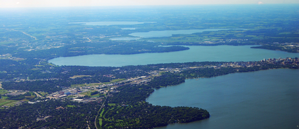
Yahara’s Land
Glaciers receded from the watershed 14,000 years ago, creating a relatively flat landscape marked by former glacial lake beds, moraines, and drumlins. In their wake, the glaciers left sediments that became the rich topsoil that now supports Yahara’s farmland.
The glacial debris also created Yahara’s chain of lakes. The debris filled the pre-glacial Yahara valley, damming the river. Where water subsequently pooled on the landscape became Lakes Mendota, Monona, Waubesa and Kegonsa.
Before European settlers arrived in the mid-1800s, the land was a mosaic of prairie, wetland, oak savannah, and forest. Remnants of these ecosystems still exist today.
The watershed’s land is now largely agricultural; corn, soybean and dairy are the main operations. The state capital, Madison, is the most densely populated urban area.
This mix of land uses creates complexity in the interaction between land and water.
Yahara’s Water
Freshwater is central to the region’s cultural identity and well-being. The Yahara River and Lakes are the major surface water bodies, which serve people’s recreational needs and provide wildlife habitat. People rely on a rich supply of groundwater for drinking water and irrigation.
Yahara’s water has long faced competing demands. It must support working farmland, densely populated and growing urban and residential areas, and a scattering of natural areas. These demands have negatively impacted water over time.
Challenges to keeping Yahara’s water clean and in sufficient supply include the following:
- Excessive amounts of nutrients—namely, phosphorus and nitrogen—have built up in the soil, primarily due to livestock manure and the heavy use of agricultural fertilizers, but urban household fertilizers have also played a role. Rain and snow melt then wash the nutrients into waterways, which lead to unsightly and unsafe blue-green algae blooms in the lakes.
- Common types of land management and infrastructure have caused soil erosion, worsened flooding risks, and increased nutrient runoff.
- Despite much effort, policies and collective practices have not yet been successful in reducing human impacts on land and water at the rate and scale necessary for long-term resilience.
- While Yahara residents love their lakes, individual behaviors and choices still don’t universally reflect the need to minimize human impacts on water and land.
Yahara’s Climate
Climate change is already having an impact in the Yahara Watershed. Since 1950, the growing season has lengthened, the number of very cold days has decreased, and extreme rains have become more frequent, among other changes.
Scientists predict southern Wisconsin will continue to experience more extreme weather under climate change. More frequent and severe storms and droughts, especially, will threaten Yahara’s communities and magnify the need to adopt water and land management policies and practices that will enable the region to adapt to the changes and sustain its resources into the future.
The Wisconsin Initiative on Climate Change Impacts provides an in-depth look at how climate change could affect life across the state.
Why Study a Watershed?
To understand the resilience of society and ecosystems, it is useful to study regions that have natural boundaries and are large and complex enough to be interesting.
Watersheds have natural boundaries defined by topography and water flow. Because of this, many decisions about land and water are made at the watershed-scale.
In the Yahara Watershed, there are fascinating interactions between land, lakes and humans that take place at a meaningful scale. Therefore, examining long-term change in the Yahara Watershed was ideal for WSC.
